Trading Trowels for Spoons: Post Holapalooza
 |
| Exposed bedrock surface of Locus B area of the Smallpox Bay site. Red markers indicate features cut into Bermuda's hard limestone bedrock surface. |
Team members paired up and picked individual features on the rocky plain we had exposed. Some of the features turned out to be natural depressions - clefts or root holes made hundreds or thousands of years before humans arrived. Others turned out to be still-born cuts, where someone started to dig a hole but then apparently stopped and shifted elsewhere. Both of these types of features either had no artifacts or only bones and charcoal - naturally occurring prehistoric material.
Many, however, were unmistakably post holes, with vertical sides and round or square plans. Three distinct types emerged: large round or square postholes measuring roughly 15 inches in diameter and 18-24 inches deep indicative of deeply seated posts, smaller shallower round post holes measuring 6-8 inches in diameter, and finally regularly occurring quite small and very shallow post cuts that perhaps represented a fenced enclosure rather than a structure. The students mapped these in plan and profile, enabling tentative associations and interpretation.
In Virginia and on other North American historical sites, post holes can provide dating evidence for both the construction and abandonment of a house, since post holes typically have fill inside the initial cut and then within that a second post mold fill feature of material deposited when the post was removed. Although mere inches apart, a coin or pottery sherd in the hole fill and the mold fill could be deposited decades apart, one by a house builder and the other by someone scavenging an abandoned home.
Bermuda's limestone pebbly sandy loam soil unfortunately does not preserve these distinctions, but in several cases it was clear that broken building stone and mortar fragments were packed post hole fill after the posts were removed.
 |
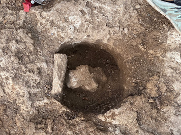
| Locus A post hole. Note the flat southern face |
Peyton had personal experience with digging post holes on his family's farm in Texas and provided me with a compelling explanation for an odd trait I had noted in quite a few Bermudian post holes. Many otherwise round features had an asymmetrical notch on one side, like a sprue to a casting.
Peyton noted that to firmly seat a post in the US, the digger tamped down the soil around the post to compact it, but this would have been impossible with Bermuda's loose soil, leaving the post to rattle around in the somewhat larger hole into which it had been inserted. The solution? Drive in a shim or wedge vertically alongside the post to cinch it firmly against the other side. Suddenly the odd notches made sense: they were reflections of stones or wooden stakes used when structures were built, but which were removed when posts were taken out.
 In one exceptional case in a Locus A post hole, we found a cut stone wedge still in situ, and a large piece of mortar that had fallen into the post mold after the post had been removed. The post hole in question turned out to be more than one Olivia-arm deep (at least 18 inches), which made excavating the bottom challenging.
Analysis of the post hole configurations and their associated fill will extend into the fall and require careful mapping within ArcGIS, but preliminary findings indicate at least three lines of posts of different sizes.
 |
| A pair of nearly touching post holes, perhaps reflecting a repair. Note that one is round while the other is square-shaped. |
There appears to be two or three different periods of early occupation, or persistent occupation of the area after the initial Summer 1612 town building episode.
This interpretation stems from the fact that some locations had two or three posts dug in close or even overlapping proximity, suggesting repairs were made over time to a long-standing structure. (Alternatively, the initial builders may have dug their first post holes off-line and then created a second one close by to remedy their mistake.)
One line of six-inch diameter square posts dates to the eighteenth century, given the presence of Creamware and a hand-blown bottle neck and lip in the fills of two post holes. The size and spacing of these features suggest a fence line rather than a building, perhaps demarcating a boundary during the period when the site was used for quarantining contagious infected arriving passengers and sailors.
After all of the post holes across Locus B were excavated (nearly fifty of them), we turned our attention to The Pit - our surprise feature in Locus A mere meters from the Smallpox Bay stone ruin, found only after a vicious battle with an old enormous fiddlewood tree.


Comments